
Dholera Activation Area: 22.54 Sq Km Development Zone & 2026 Status

Key Highlights
The Dholera Activation Area is the first major development zone within the Dholera Special Investment Region (DSIR) in Gujarat. Spread across approximately 22.54 sq km, it mainly covers 18 sq km of TP2 East and around 4.5 sq km of TP4. As of 2026, Government of India information describes the Activation Area is completed and operational, with major infrastructure already established. This makes it one of the most important areas for understanding the actual on ground development of Dholera SIR.
Key Features of the Dholera Activation Area
| Detail | Information |
|---|---|
| Total Area | Approx. 22.54 sq km / 2,254 hectares |
| Location | Dholera SIR, Gujarat |
| TP Coverage | Mainly TP2 East and part of TP4 |
| Internal Roads | Approx. 72 km |
| Development Role | Initial development and catalyst zone |
| Current Status | Completed and Operational |
What is the Dholera Activation Area?
The Dholera Activation Area is the first major development zone of Dholera SIR, covering approximately 22.54 sq km. It was planned to establish essential infrastructure such as roads, utilities, water supply, drainage and other urban services before development expanded across the wider Dholera region.
Dholera SIR covers approximately 920 sq km, but the entire area is being developed in phases. The Activation Area was selected as the initial zone because of its strategic location and availability of government land, making it suitable for early infrastructure development and industrial activity.
The main purpose of the Activation Area is to create a ready infrastructure base for businesses, industries and future urban development within Dholera SIR.
Infrastructure in the Dholera Activation Area
One of the key features of the Dholera Activation Area infrastructure is the development of common services required for industries and future urban development.
Infrastructure planned and developed in the area includes:
- Approximately 72 km of internal roads and underground services
- Water supply and treatment infrastructure
- Sewage treatment systems
- Common effluent treatment facilities
- Storm-water drainage
- Power distribution infrastructure
- ICT and communication networks
- Smart monitoring and administration systems
Also 50 MLD Water Treatment Plant, 10 MLD Sewage Treatment Plant and 20 MLD Common Effluent Treatment Plant as part of Dholera's infrastructure development.
The ABCD Building (Administrative and Business Centre for Dholera) supports administration and smart city monitoring through integrated digital systems.
What is the Dholera Activation Area Status in 2026?
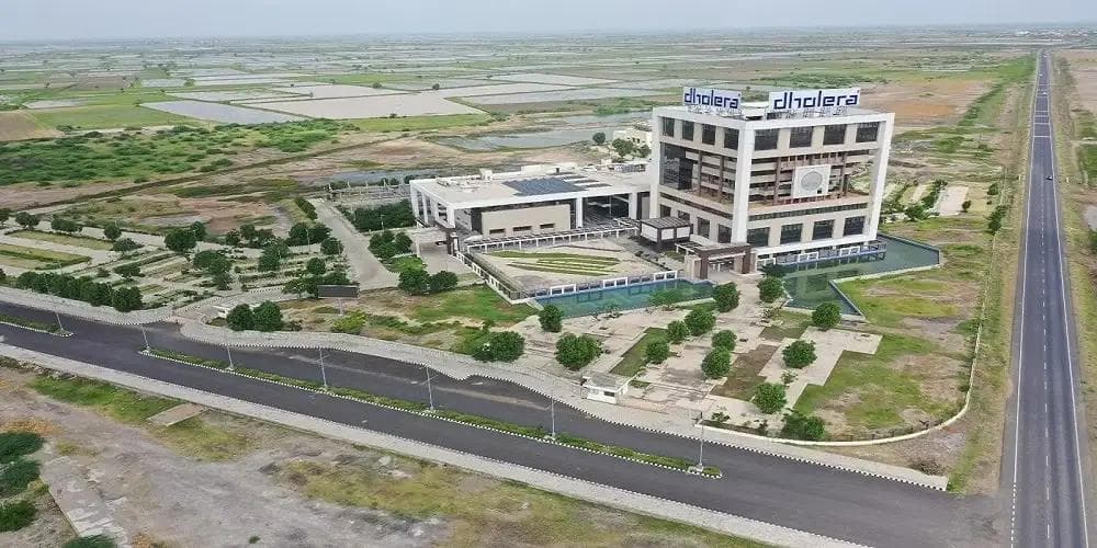
As of 2026, the Dholera Activation Area is fully completed and operational, with major infrastructure, internal roads, utility networks, and essential services established. Spread across approximately 22.54 sq km (2,254 hectares) within Dholera Special Investment Region (Dholera SIR), Gujarat. Further, it serves as the initial development zone of Dholera Smart City. The operational infrastructure supports planned industrial, commercial, and urban activities and provides a foundation for Dholera’s wider development.
Connectivity to the Dholera Activation Area
Dholera's connectivity has improved significantly with the development of the Ahmedabad-Dholera Expressway, an access controlled greenfield corridor of more than 109 km.
The expressway improves road connectivity between Ahmedabad and Dholera SIR and is expected to support industrial movement as well as passenger travel.
The Government has also approved the Ahmedabad-Dholera semi-high-speed double railway line, which is planned to connect Ahmedabad with Dholera SIR, airport and the Lothal region. Dholera International Airport is another major connectivity project being developed in navagam near DSIR.
Why is the Dholera Activation Area Important?
The Dholera Activation Zone provides a practical way to understand the difference between Dholera's long term master plan and infrastructure already developed on the ground.
For businesses, it represents one of the first areas with concentrated planned infrastructure. For property buyers, it provides an important reference point for comparing TP schemes, location, connectivity and proximity to developed infrastructure.
Conclusion
The Dholera Activation Area is a key developed zone within Dholera SIR, covering about 22.54 sq km with major infrastructure already established. As of 2026, it is almost complete and benefits from improving road, rail and airport connectivity. For investors and businesses, it provides an important reference point for understanding Dholera’s current development and future potential.
FAQs
Q. How big is the Dholera Activation Area?
The Dholera Activation Area covers approximately 22.54 sq km, or around 2,254 hectares.
Q. Which TP includes the Dholera Activation Area?
It mainly includes approximately 18 sq km of TP2 East and around 4.5 sq km of TP4.
Q. Is the Dholera Activation Area fully developed?
As of 2026, Dholera Activation Area is fully developed and operational.
Q. Is the Activation Area the same as Dholera SIR?
No. Dholera SIR covers approximately 920 sq km, while the Activation Area is a smaller 22.54 sq km initial development zone.


