
Table of Contents
- Understanding the Dholera Riverfront Vision
- How Riverfront Projects Increase Land Value
- Impact on Residential Plot Development & Commercial and Mixed-Use Plots
- Residential Plot Development
- Commercial and Mixed-Use Plots
- Infrastructure Boost Around the Riverfront
- Urban Lifestyle & Social Infrastructure Impact
- Investment Perspective: Early vs. Post-Development Entry
- Future Outlook: Riverfront as a Growth Multiplier
- Conclusion
- Frequently Asked Questions
Dholera Smart City is India’s first greenfield smart city under the Dholera Special Investment Region, developed with plug-and-play infrastructure, industrial zoning, and phased long-term planning. The riverfront is a core part of this infrastructure-driven growth framework..
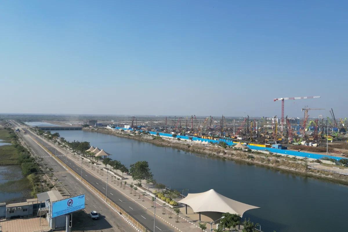
In the context of Dholera Special Investment Region, the Dholera Riverfront is not an afterthought. It is embedded into the master plan of Dholera Smart City. This 6 km engineered canal corridor integrates drainage systems, mobility access, green spaces, and zoning strategy within the Activation Area.
As part of the broader Dholera Smart City project, the riverfront reflects how smart city projects in India are moving toward infrastructure-led urban growth rather than unplanned expansion.
Understanding the Dholera Riverfront Vision
The Dholera Riverfront, often referred to as the Canal Front, stretches approximately 6 km in length, with a width of around 110 metres and depth of 15 metres. It is designed as an artificial water channel that performs both technical and urban functions.
Its primary objectives include:
- Structured stormwater management
- Public recreational space
- Alignment with plug-and-play infrastructure
- Enhancement of surrounding zoning sectors
Located within the Dholera activation area (22.5 sq. km), the riverfront benefits from operational trunk infrastructure. Roads, underground utilities, ICT systems, and drainage networks are already in place, supporting Dholera Smart City infrastructure development.
How Riverfront Projects Increase Land Value
Globally, waterfront developments influence land utilization patterns and long-term valuation trends. While value appreciation depends on multiple factors such as infrastructure readiness, connectivity, and policy alignment, riverfront corridors often become urban anchors.
In Dholera SIR Smart City, the riverfront provides:
- Visual and environmental enhancement
- Reduced flood risk due to engineered drainage
- Organized urban structuring
- Accessibility through major corridors
Riverfront projects act as powerful economic catalysts that transform underutilised land into premium real estate. In the Dholera Special Investment Region (DSIR), the planned waterfront is designed as a strategic urban asset to drive long-term stability and value in the Activation Area.
How it Works
- Infrastructure Synergy: Projects integrate flood protection and roads, making nearby plots "development-ready" and safer for investment.
- Lifestyle Appeal: Parks and promenades increase "liveability," driving up demand for premium residential and commercial spaces.
- Market Anchoring: When authorities auction reclaimed land at high rates, it raises the price floor for all surrounding plots.
Case Study: Sabarmati Riverfront (Ahmedabad)
The Sabarmati Riverfront in Ahmedabad is the blueprint for Dholera:
- Price Surge: A recent auction reached a record ₹3.52 lakh per sq. metre, proving that structured waterfronts create massive value.
- Self-Funding: The project recovers its ₹1,200 crore cost by selling only 14.5% of reclaimed land, leaving the rest for public use which further boosts nearby property values.
Impact on Dholera Plot Prices
Land in Dholera’s Activation Area has already risen by 35% over the past year. The riverfront is expected to further boost growth, with plots near the waterfront likely to command higher premiums and support a 2–3x increase in value by 2025.
Impact on Residential Plot Development & Commercial and Mixed-Use Plots
Residential Plot Development
The presence of a riverfront corridor typically influences how residential sectors are planned. In Dholera, zoning regulations under Dholera SIR ensure systematic development rather than fragmented layouts.
Dholera residential plots near structured infrastructure corridors benefit from:
- Planned green spaces
- Organized road networks
- Access to drainage and utilities
- Integration with social infrastructure
As Dholera Smart City Progress continues and hospitals, schools, and civic facilities expand in the Activation Area, residential planning around the riverfront is likely to strengthen over time.
For those evaluating Dholera Smart City plots or Dholera SIR plots, proximity to infrastructure-ready zones is often a key planning consideration.
Commercial and Mixed-Use Plots
Waterfront corridors frequently support commercial activity due to accessibility and visibility. In Dholera, the riverfront’s location near administrative and industrial clusters enhances its strategic importance.
The presence of the ABCD Building, along with industrial growth including initiatives such as Tata Semiconductor, contributes to long-term demand for structured commercial ecosystems.
Dholera commercial plots in infrastructure-backed zones may gradually align with industrial, institutional, and service-sector expansion.
Infrastructure Boost Around the Riverfront
Infrastructure is the backbone of the Dholera Smart City project. The riverfront is located within the fully serviced Activation Area, where plug-and-play infrastructure is already present.
Key infrastructure elements include:
- Underground drainage systems
- Power distribution networks
- Water supply pipelines
- ICT-enabled urban systems
The upcoming Dholera International Airport will improve access to the riverfront, making residential and commercial plots nearby more attractive and boosting their long-term value.
As industries in Dholera expand and upcoming projects in Dholera progress, infrastructure around the riverfront is positioned as a foundational growth corridor within the Gujarat smart city framework.
Urban Lifestyle & Social Infrastructure Impact
Urban planning today emphasizes balanced growth between industry and livability. The Dholera Riverfront integrates landscaped promenades, public spaces, and pedestrian corridors, contributing to quality-of-life standards.
Recent Dholera activation area latest news indicates continued development of healthcare facilities, educational institutions, and civic infrastructure within close proximity.
Public realm planning supports:
- Walkable urban zones
- Community engagement spaces
- Green environmental buffers
This integration strengthens the residential appeal of smart city Dholera and aligns with the long-term development vision of Dholera SIR Smart City.
Investment Perspective: Early vs. Post-Development Entry
Large-scale smart city projects in India typically evolve in phases. Early-stage entry often occurs during infrastructure development, while post-development entry follows operational readiness.
Within Dholera SIR, the Activation Area provides a unique case where trunk infrastructure is already functional. For those studying Dholera Smart City investment dynamics, proximity to infrastructure corridors like the riverfront may represent structured planning alignment rather than speculative expansion.
However, long-term growth depends on phased execution of industrial projects, connectivity milestones, and social infrastructure completion. Monitoring Dholera Smart City Progress and activation area developments remains essential.
Future Outlook: Riverfront as a Growth Multiplier
Looking ahead, the riverfront may act as a structural growth multiplier within the Dholera Smart City project. As connectivity improves and industrial ecosystems expand, the corridor could influence zoning evolution and mixed-use integration.
With renewable initiatives like Dholera Solar Park, semiconductor manufacturing initiatives, airport connectivity, and expressway access, the broader ecosystem strengthens the foundation of Dholera SIR.
The long-term master plan extending toward 2042 ensures phased, policy-backed expansion rather than rapid, unstructured growth.
Conclusion
The impact of Dholera Riverfront on Surrounding Development lies not merely in aesthetics but in infrastructure integration. As part of Dholera SIR Smart City, the 6 km engineered corridor combines flood management, connectivity, zoning alignment, and public realm planning.
Located within the Activation Area with plug-and-play infrastructure already in place, the riverfront supports structured residential and commercial planning. Connectivity through the Ahmedabad-Dholera Expressway and future airport access further enhances regional integration.
In the broader landscape of smart city projects in India, Riverfront Development in Dholera reflects a long-term infrastructure-first strategy, one that may shape surrounding plot development patterns for decades.
Frequently Asked Questions
Q. What is the Dholera Riverfront project?
A. The Dholera Riverfront is a planned 6 km engineered canal corridor inside the Activation Area of Dholera Smart City, designed to support drainage, mobility, green spaces, and structured urban growth.
Q. Is Dholera good for long term investment?
A. Yes, Dholera Smart City is backed by government and industry giants. Dholera ensures long term appreciation with ₹6 Lakh Crore+ investment and global connectivity.
Q. What are the upcoming mega projects in Dholera Smart City?
A. Dholera is home to many mega projects including the TATA Semiconductor Plant, Dholera International Airport, Ahmedabad-Dholera Expressway, and Dholera Solar Park by TATA Solar and Gujarat Govt.
Q. How can the Dholera Riverfront affect plot prices?
A. The Dholera Riverfront can support plot price growth by improving infrastructure readiness, accessibility, livability, and overall planning value in nearby sectors.
Q. What should buyers check before investing near the Dholera Riverfront?
A. Buyers should check exact location, zoning relevance, road connectivity, infrastructure readiness, legal clarity, and how closely the plot is linked to actual development corridors before investing near the Dholera Riverfront.


